7 Days
1-15
English, Swahili
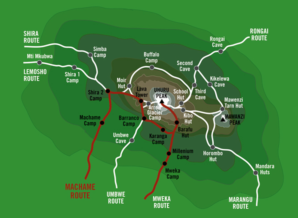
The Machame Route, often called the “Whiskey Route,” is one of the most popular and scenic paths to the summit of Mount Kilimanjaro. Known for its stunning views, diverse landscapes, and high success rate due to excellent acclimatization, this 7-day trek allows climbers to experience rainforests, moorlands, alpine deserts, and glaciers before reaching Uhuru Peak (5,895m / 19,341ft), the highest point in Africa. The route involves some steep sections, including the famous Barranco Wall, but does not require technical climbing skills. Climbers must be physically prepared and expect altitude challenges, especially on summit night. The journey follows the “climb high, sleep low” strategy, improving acclimatization and increasing the chances of a successful ascent. Below is a detailed breakdown of each day’s trek.
Highlights.
The journey begins at Machame Gate, where climbers register with the park authorities before starting the ascent. The first day’s hike takes you through a lush rainforest, characterized by tall trees, thick undergrowth, and a humid atmosphere. The well-defined trail can be muddy and slippery, especially after rain, so good trekking boots are essential. This section is home to various wildlife, including blue monkeys, colobus monkeys, and tropical birds. As you ascend, the dense forest gradually thins out, and after several hours of trekking, you arrive at Machame Camp. Nighttime temperatures drop significantly, so warm clothing is necessary.
The second day begins with a steep ascent, leaving the rainforest behind and entering the moorland zone. The vegetation changes dramatically, with giant lobelias and Senecio trees dotting the landscape. This is the first real challenge of the climb, as the air gets thinner, and some climbers may experience mild altitude symptoms like headaches. The Shira Plateau offers incredible panoramic views of Kilimanjaro’s peak and Mount Meru in the distance. After reaching Shira Camp, temperatures drop further, often below freezing at night, making this a much colder night than the previous one.
Morning: Ascent to Lava Tower
Afternoon: Descent to Barranco Valley
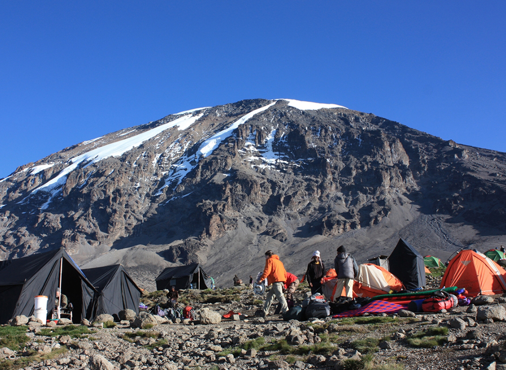
Today’s hike will be a mixture of uphill and downhill. The hike begins by taking you up a gradual ridge through a rocky, desert environment until you reach the Lava Tower, which is a 300 ft. free-standing volcanic rock formation. Upon reaching the Lava tower, you will descend through the Senecio Forest to Barranco camp. This day is crucial for acclimatization, as the route follows the “climb high, sleep low” principle. The trek gradually ascends to Lava Tower (4,630m / 15,190ft), a volcanic formation where altitude sickness symptoms may become more noticeable. The landscape becomes rocky and barren, resembling an alpine desert with very little vegetation. After a short break at Lava Tower, the trail descends sharply to Barranco Camp, giving your body time to adjust to lower altitudes. The camp is surrounded by the breathtaking Barranco Valley, with views of the imposing Barranco Wall, which will be climbed the next day.
The morning begins with you scrambling up the almost vertical Barranco wall! If you have extra time before breakfast, take a moment to step out and watch as others begin to ascend the wall. The hikers look like tiny colorful ants as they ascend the cli. Don’t worry, Barranco wall is a manageable climb, which takes only 90 minutes to 2 hours. Most people get to the top and think, ‘That wasn’t nearly as scary as it looked!’. It is steep, but anyone can do it. Upon reaching the top of Barranco wall, take in the spectacular sights; this is a great photo opportunity with the summit of Kilimanjaro in full view! This is a shorter trek, allowing more time for recovery and acclimatization. At night, the temperature drops below freezing, and the air becomes increasingly thin.
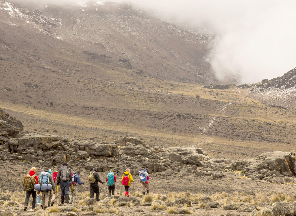
The ascent continues through an arid and rocky landscape toward Barafu Camp, the final stop before the summit attempt. The air is thin, making every step feel more exhausting. Barafu means “ice” in Swahili, which reflects the harsh, windy, and extremely cold conditions here. Climbers reach camp in the afternoon and are advised to rest as much as possible before the final ascent. After an early dinner, most climbers sleep by 7 PM to prepare for a midnight wake-up call for the summit push. You leave Karanga camp and reach a junction that connects with the Mweka trail. You will continue up a rocky section to Barafu Camp. Be sure to check out the view of Mount Meru in the distance. People often enjoy hiking Mount Meru as well! Mount Kilimanjaro has three specific peaks or volcanic cones named “Kibo”, “Mawenzi”, and “Shira”. Both Mawenzi and Kibo are viewable from Barafu camp, ask your guide to point them out to you!
Your guides will wake you an hour before you are to leave for the Summit. Depending on the pace which your guide sets for your summit attempt, they will most likely wake you between 11 PM and 2 AM. Wear multiple layers of clothing, it will be very cold during your hike up. The most challenging and rewarding day begins just before midnight. Climbers set out in freezing temperatures (-20°C / -4°F), using headlamps to navigate the steep and slow climb to Stella Point (5,756m). This section is both mentally and physically exhausting, requiring strong determination. After Stella Point, a final push leads to Uhuru Peak (5,895m), the highest point in Africa. Reaching the summit at sunrise offers breathtaking views of glaciers, the crater, and the vast landscape below.
The final day is a relaxed descent through the rainforest, where the air becomes warmer and more humid. Climbers often feel refreshed and energized after conquering the summit. Upon reaching Mweka Gate, climbers receive their summit certificates, marking the successful completion of the Kilimanjaro climb. From here, tourist is transferred back to Arusha or Moshi for celebrations and much-needed rest.

About
We are a team of adventure enthusiasts who love everything about Tanzania. Our team arrived here in 2022, and we were immediately fascinated by this land. Read More…
Copyright © 2025 All Right Reserved Asili Safaris
WhatsApp Us