
9 Days
1-15
English, Swahili
The Northern Circuit Route is the longest and most scenic route on Kilimanjaro. It offers the best acclimatization prole, making it one of the easiest routes to succeed in reaching the summit despite its long duration. The route circles the mountain from the west to the north, providing stunning panoramic views and fewer crowds. This route is ideal for adventurous trekkers who want a remote and peaceful climb, as it passes through less-traveled areas of Kilimanjaro. It follows the Lemosho Route for the first few days but then diverts north, offering a unique experience compared to other routes.
Highlights.
Arrival at Kilimanjaro International Airport for your climb When you arrive at Kilimanjaro International Airport our Asili Tour guide is there waiting for you. He then drops you at your hotel, where you can relax from your flight. Preparation for your climb: You meet your guide before the start of your climb, where he briefs you and offers advice on what to wear, what to pack, and other important tips to make your climb as comfortable as possible.
Your adventure starts at your hotel, where your driver picks you up and drives you to Londorossi Gate (on the west side). You then go to Lemosho trailhead for lunch and begin the climb. This easy walk-through dense rainforest lasts 3 to 4 hours and offers the chance to spot various animals, including buffalo and monkeys. After a narrow path and a few steep sections, you reach Big Tree Camp (Mti Mkubwa) where you spend the night.
Terrain: Heath and Moorland Leaving the rainforest behind, climbers enter the heath and moorland zone, with giant heather and lobelias covering the landscape. The trail climbs steadily toward the Shira Plateau, a vast high-altitude desert formed by volcanic activity. The day ends at Shira 1 Camp, where climbers get their first clear views of Kilimanjaro’s glaciers.
Today’s hike lasts 7-8 hours and takes you from Heather into the alpine desert. You pass the Shira Plateau, one of the highest in the world, on the way to the Lava Tower, with an optiofinal visit to the Shira Cathedral. From the Lava Tower, the path continues northwest toward Kibo, the highest peak of Kilimanjaro. Afterwards, the day ends at Shira 2 Camp, where trekkers will experience colder temperatures at night.
Climbers now leave the southern routes and enter the Northern Circuit, a rarely traveled path that offers incredible views of the Kenyan plains. The trail ascends gradually, passing Lava Tower (4,600m / 15,091ft), a famous rock formation where climbers take a short break before descending slightly to Moir Hut, an isolated camp nestled beneath steep cliffs.
As you continue the route on the Northern Circuit, you get over a steep ridge along the main path. Today's hike lasts about 8 to 9 hours, taking you through heathland and alpine desert to Bu‑alo Camp. In the morning, you have the option to make a quick detour to Little Lent Hill.The trail includes a moderate ascent, offering breathtaking views of the glaciers, craters, and vast open plains. The day ends at Buffalo Camp, where the temperatures drop sharply at night.
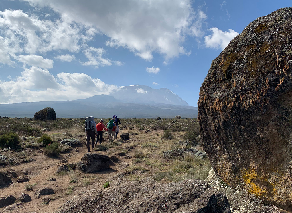
On the fifth day on the mountain, you continue across diverse landscapes, including heathland, valleys, and alpine environments. The Northern Circuit route heads eastward and is less frequented, allowing for a peaceful experience of the scenery, wilderness, and stunning mountains. This trek takes approximately 5 to 6 hours. The hike is relatively short, allowing climbers to rest and further acclimatize at Third Cave Camp.
The final day before the summit push is a gradual climb through barren landscapes leading to School Hut, the last high-altitude camp. Climbers eat early and rest in preparation for the midnight summit attempt. Today involves a 4-5 hour climb to reach the "Saddle", a stunning lunar landscape between Mawenzi and Kibo Peaks. From there, you continue to School Hut Camp, arriving in the early afternoon. You have the rest of the day to relax and prepare for the final ascent the following day.
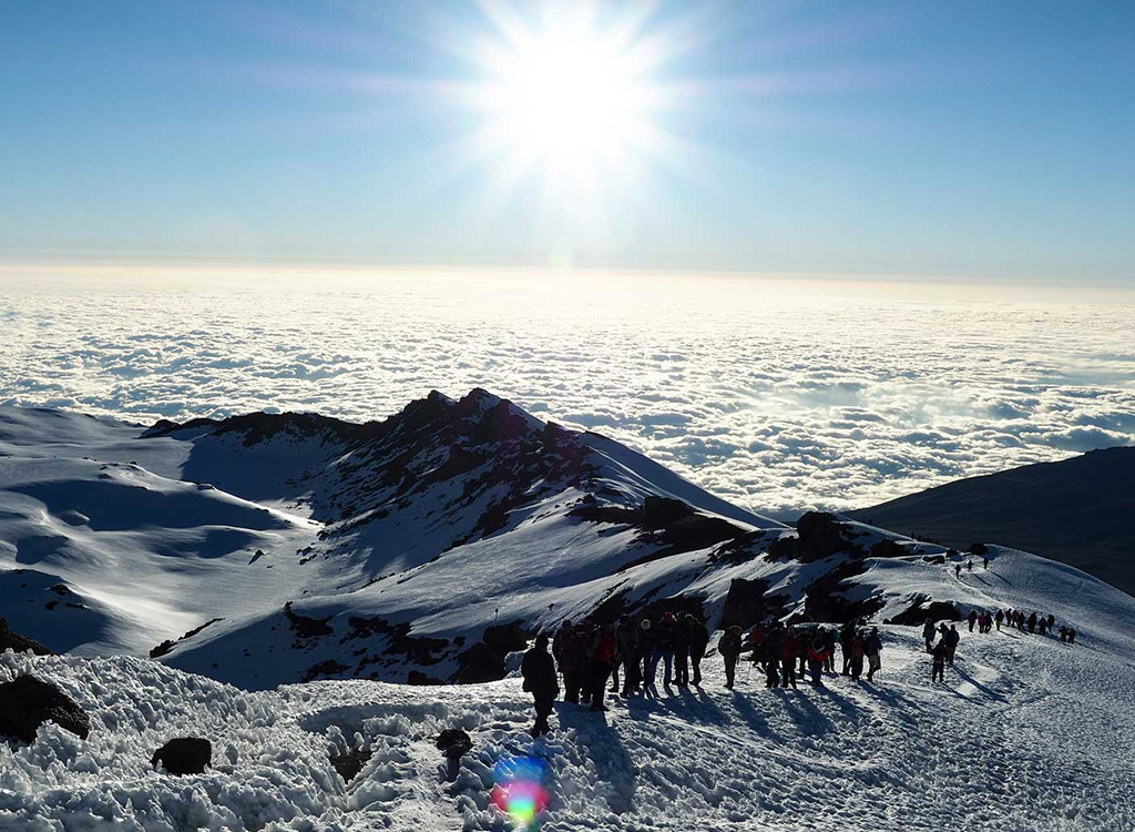
Summit day! The summit attempt begins at midnight, following a steep slow ascent to Gilman’s Point (5,685m). The goal for you and numerous other climbers is to reach the peak right at sunrise. In reality, due to differences in hiking speed, energy, and altitude acclimatization, there is a several hour span where most climbers reach the summit. Using headlamps (bring extra lithium batteries, which last much better in cold dark conditions!) you will ascend 6-7 hours to Gilman’s point, traverse the Crater Rim to Stella Point and then up another 1-2 hours to Uhuru Peak, the summit. After celebrating at the summit, climbers descend back to School Hut, take a short break, and continue down to Mweka Camp, where the air feels richer in oxygen.
Finally, you appreciate the drop in altitude. After breakfast, you walk to the national park's exit. Following the descent, the group gathers to congratulate each other. Your driver takes you back to the hotel, where you enjoy a shower, a delicious dinner, and a well-deserved rest.
Additional Information Things to bear in mind:
You’ll be hiking slowly, but ‘slowly’ at altitude can feel more like a run at sea-level You need to be able to hike 6-8 hours a day, then do it all over again the next day, and the day after Summit night/day can be 10+ hours on your feet The trails can be steep, rocky and uneven. Mental stamina and mindset are very important
Don’t forget:
Wear your hiking boots during practice hikes, at the gym or around the house. Especially new boots, you want them well broken-in. Experiment with different sock combinations. Practice wearing your daypack (put some weight in it) to get your shoulders and back used to hiking with it Practice layering your clothes: how do the layers t, and getting them on and o‑ quickly Hiking poles: if you’re planning to use them on the mountain.

About
We are a team of adventure enthusiasts who love everything about Tanzania. Our team arrived here in 2022, and we were immediately fascinated by this land. Read More…
Copyright © 2025 All Right Reserved Asili Safaris
WhatsApp Us